


Panchià-Passo Rolle-Valles-San Pellegrino-Vigo di Fassa-Passo Costalunga-Lago Carezza-Passo Lavazè-Panchià


Panchià-Passo Rolle-Valles-San Pellegrino-Vigo di Fassa-Passo Costalunga-Lago Carezza-Passo Lavazè-Panchià
![]()

![]()
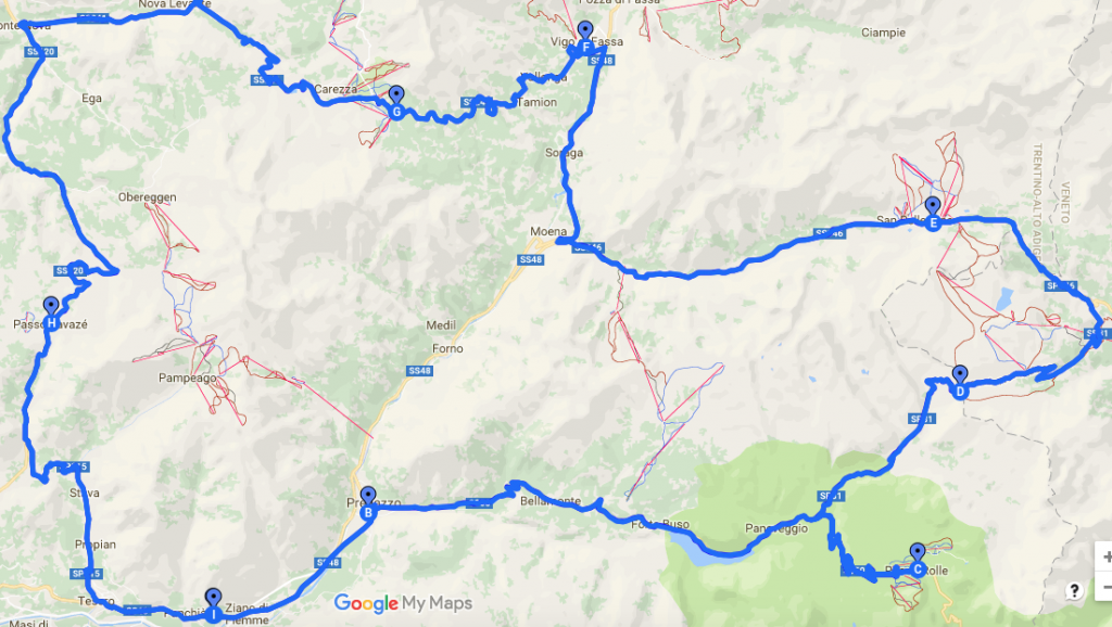
Our tour begins in front of the Hotel Panorama, from where we descend for about 200 meters and turn left at the intersection with the state road of the Dolomites (SS 48). Through Ziano di Fiemme we continue to Predazzo, which we reach after a large roundabout. Predazzo is the seat of Scuola alpina della Guardia di finanza (the Alpine School of the State Financial Services), which lies close to the creek Travignolo we cross to reach another roundabout. Here we turn towards Passo Rolle and take the road that winds through forests, meadows and pastures. After about 3.5 kilometers we reach Bellamonte and thus the Nature park Paneveggio – Pale di San Martino, a nature reserve since 1967 with an area of almost 20,000 hectares.
Passing the Lake Forte Buso and its impressive dam, we come to the visitor center of the Nature Park. Here we suggest you to make a stopover, because the chances are great to observe deer or roe deer. You should also take some time to give a closer look at the forest around. From here comes the wood from which countless musical instruments – including the Stradivari violins are made of.
Leaving the visitor center and forest behind us, we arrive at the intersection of the roads to the Passo Valles and Passo Rolle. We take the one towards Passo Rolle and continue straight ahead until just before the pass at 1984 meters, where we enjoy a stunning view of the Pale di San Martino. They cover 240 square kilometers in the provinces of Trentino, Belluno and Veneto, making them one of the largest massifs of the Dolomites.
Leaving this panorama view behind us, we return to Paneveggio on the same road we came from. This time, just before the Nature Park Center, we turn right onto the road to Passo Valles. This road winds first through the forest, at some parts the creek Travignolo along, until we reach the turn off towards Pian dei Casoni. We continue straight ahead and soon we reach the first turn off onto the road to Passo Valles. It runs almost continuously, for about five kilometers, steeple upwards with gradients in the double-digit range. The pass itself lies at 2032 meters above sea level.
From Passo Valles we plunge towards Falcade keeping in sight Cime di Focobon and Civetta all the time. After a few kilometers we reach a crossroads, which is in the middle of a wide hairpin bend. To the right the road would lead us down to Falcade and Cencenighe, but we keep to the left and climb up again. “Uphill” is almost an understatement here, as the road to the Passo San Pellegrino has a rise of 20 percent. However this is not a problem riding on the bike and so we have time to admire the forests, pastures and a small reservoir before we reach the pass at 1918 meters.
From the pass we dive to Moena and after about twelve kilometers we follow the signs for “Canazei/Val di Fassa”. Crossing a tunnel and the village of Soraga, before heading for a long, slightly ascending straight section past a riding stable (to the right), we arrive at San Giovanni. Here we turn left at the first crossroads and turn towards Vigo di Fassa and Passo di Costalunga. We enjoy both the view of Val di Fassa and Catinaccio. We drive round Vigo di Fassa on the left and this way we also drive past the cable car leading to Ciampedie at 2000 meters. Ciampedie is a ski paradise in winter. In the summer, it is the gateway to Catinaccio and so to say the viewing balcony from which you can enjoy an incredible panorama: of Catinaccio, Torri di Vajolet and Larsec.
However, we move on to the 1753 meter high Passo Costalunga and thus to South Tyrol. The pass itself offers impressive views with the massif of Catinaccio on the right and the Latemar with its towers, turrets and battlements on the left. After a few kilometers driving down we reach Lago di Carezza, an obligatory stopp-off, before we continue to Nova Levante and to a crossroads near the village of Ponte Nova. There we turn left and go up to Passo Lavazè, a small plateau on 1805 meters above sea level framed by the peaks Corno nero and Corno bianco. This is ideal for the cross-country skiing in winter and hiking or mountain biking in summer.
Near the hotels on Passo Lavazè we take the road to drive down in the direction of Stava/Cavalese. After about four kilometers we reach an intersection where we turn left towards Stava/Pampeago and Passo Pramadiccio. We continue on the road to Stava and Tesero. Near the bridge over the Stava creek we reach the crossroads and turn left onto the state road of the Dolomites (SS 48). After three kilometers drive, we arrive at Panchià. At the end of the village we turn left at the second traffic light and after a short drive uphill we are back home: directly in front of the Hotel Panorama.
Motorcycles tours
| Distance | 120km |
| Difficulty | Easy |
| Travel time | 2.30h |
Albergo Panorama ***
Via Templari, 51 - I-38030 Panchia' (TN) Val di Fiemme info@albergopanorama.it T. +39 0462 813137 F. +39 0462 810136 M. +39 335 74 29 377 GPS N 46.286335 E 11.548111 Vat number 01096690225